The 1989 Newcastle earthquake: 10.27am, 28 December
A moderate earthquake under Boolaroo, three days after Christmas, killed 13 people and damaged 50,000 buildings. It was one of the worst natural disasters in Australian history.
By Ruth Ellery · First published · 2 min read
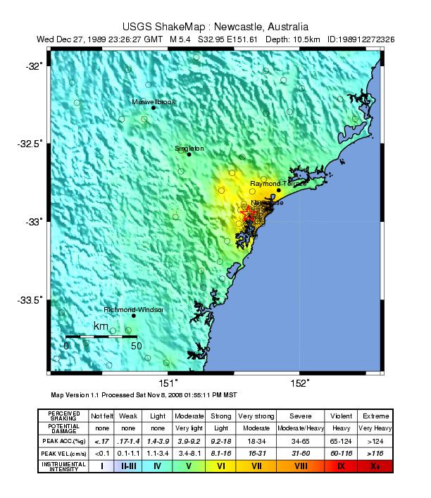

At 10.27am on Thursday 28 December 1989 the ground under Newcastle moved. The earthquake measured 5.6 on the local magnitude scale (5.4 on the moment scale geologists now prefer), modest by world standards. Its focus was about 11 kilometres down, and its epicentre about 15 kilometres south-west of the city centre, near Boolaroo.
It was felt as far south as Batemans Bay, as far west as Dubbo and as far north as Armidale, according to the coroner's findings.
Thirteen lives
Thirteen people died. Nine were killed at the Newcastle Workers Club, where the building collapsed. Three were killed in Beaumont Street, Hamilton. One person died of shock. More than 160 were injured.
Geoscience Australia notes that the toll could have been far higher. Thousands of people were expected at the Workers Club that night for a concert, and because it was the holidays, many badly damaged schools were empty.
Why the city shook so hard
The damage was worst where Newcastle is built on the soft sediments laid down by the Hunter River, which amplified the shaking. Geoscience Australia recorded intensity VIII on the Modified Mercalli scale at many places, the level at which ordinary buildings are badly damaged.
Damage spread over 9,000 square kilometres. About 300,000 people were affected, 1,000 were left homeless, and 50,000 buildings were damaged, about 35,000 of them homes. Roads, bridges and power lines were hit.
The buildings that came through
Many of the landmarks on this site were damaged. The Customs House reopened as a hotel in 1995. City Hall's clock tower was repaired. Christ Church Cathedral's walls and piers were strengthened between 1995 and 1997 with an engineering technique new to Australia.
The earthquake also changed how the region thought about its own ground. Before it, a Geoscience Australia report says, the region's earthquake history had been "forgotten, lost or ignored", apart from older residents' memories of an earthquake at Boolaroo in 1925.
Newcastle Libraries keeps an online collection of photographs and stories from the day, and a history unit for primary school students.
The cost, and what changed
The Insurance Council of Australia estimated the insured damage at $862 million in 1989 dollars, a figure later normalised to about $3.24 billion in 2011 terms. Fifty thousand buildings were damaged. The Newcastle RSL Club had to be demolished that same afternoon, and the Workers Club, the scene of the worst damage to any building in the city, was demolished too.
The NSW State Coroner's findings in 1990 recommended a revision of the Australian earthquake code, AS 2121 (1979), and a review of engineering and architecture courses so that the effects of earthquakes on structural design were taught. Weeks later, in February 1990, heavy rain from Cyclone Nancy found leaks in buildings that had been thought sound after the quake.
Sources
- 30 years on: commemorating the 1989 Newcastle earthquake, Geoscience Australia
- Newcastle earthquake 1989: findings and recommendations, NSW Coroner, 1990
- Earthquake history, regional seismicity and the 1989 Newcastle earthquake, Geoscience Australia
- Earthquake, Newcastle 1989, Australian Disaster Resilience Knowledge Hub
- The Newcastle 1989 earthquake, Newcastle Libraries